Natural disasters like hurricanes can drastically impact lives and property, inflicting heavy losses that take years to recover from. A hurricane is a massive swirling storm system, the structure of which allows it to impact a large radius. Understanding the anatomy of a hurricane, including this unique eye, is crucial for predicting its course, preparing for its impact, and building resilient communities.
Breaking Down the Parts of a Hurricane
Before we delve into the eye of the storm, let’s comprehend the broader anatomy of a hurricane. A hurricane is a complex weather system marked by several distinct components:
1. The Eye of the Hurricane
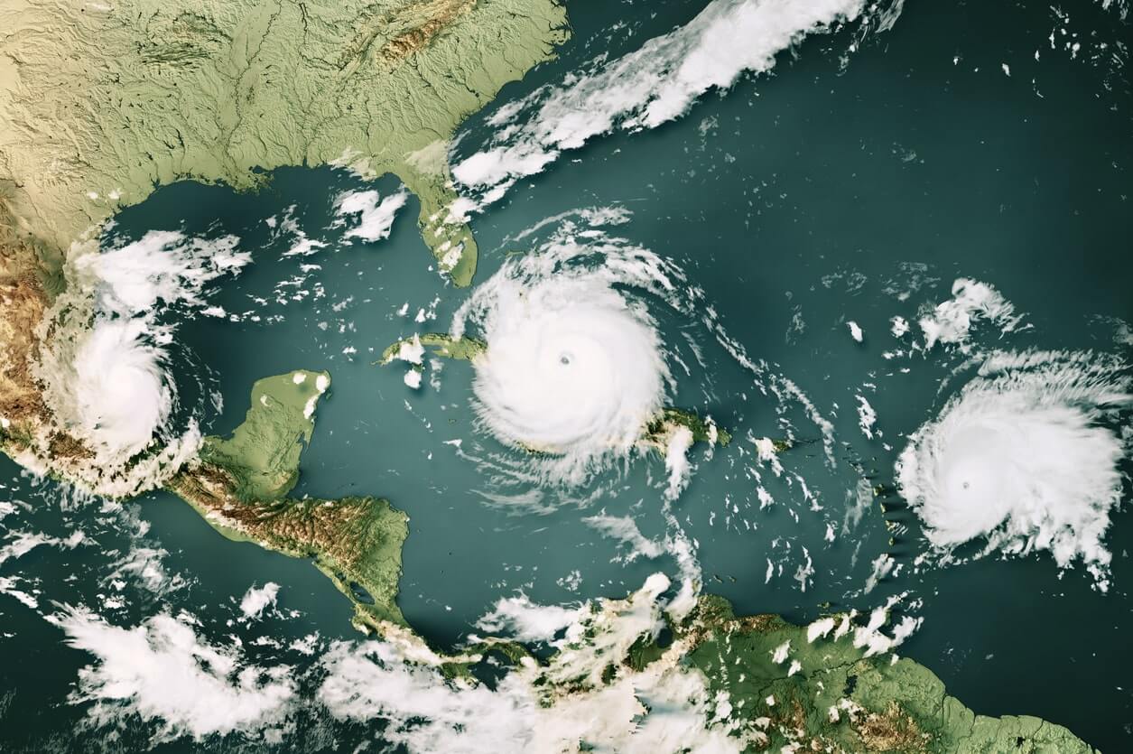
The eye of a hurricane is a zone of relative calm and clear skies at the very center of the storm. This can be disconcerting, given the severe conditions that typify the rest of the hurricane. It is typically circular or oval-shaped and ranges in diameter from about 20-40 miles, though it can be even larger in some storms. The drop in conditions within the eye can be abrupt and dramatic, with severe hurricane conditions giving way to a near-total calm.
The eye’s formation is tied to the hurricane’s intensity – only stronger hurricanes, typically category 3 or higher, form a well-defined eye. It forms because of the dynamic balance between inward-flowing and rising air and the centrifugal force acting on the air moving around the center.
The eye of the storm is a fascinating aspect of hurricane anatomy. Contrary to what you might expect, the eye is a zone of relative tranquility within the chaos of the hurricane. Here’s what makes the eye unique:
- Calm Winds: Unlike the raging winds that characterize a hurricane, the eye of the storm is remarkably calm. This is because the air doesn’t converge or come together in the eye as in other parts of the hurricane. The eye is where the wind ‘disappears,’ leaving behind an almost eerie quietness. While the exact reason for this calmness is complex, it’s partly because the rapidly rotating air around the eye, in the eyewall, doesn’t have an opportunity to enter the eye due to centrifugal forces.
- Clear Skies: As surprising as it may seem, the skies within the eye of a hurricane are often clear or have few clouds. This is due to the air within the eye sinking or ‘subsiding,’ a process that warms the air and suppresses cloud formation. This lack of clouds often results in a clear, circular patch of sky – a phenomenon sometimes referred to as the ‘stadium effect’ because the towering clouds of the eyewall resemble the stands in a giant sports stadium.
- Low Pressure: The eye is the region with the lowest barometric pressure in the hurricane. This is due to the rising warm air in the eyewall, leaving less air in the eye. The lower the pressure in the eye, the stronger the hurricane. This low pressure draws surrounding air into the hurricane, feeding its strength and growth.
It’s crucial to remember that while the eye is temporarily calm, the storm is far from over. The hurricane’s most violent conditions are just beyond the edge of the eye, in the eyewall, and will return with potentially devastating force once the eye passes.
2. The Eyewall of the Hurricane
Directly surrounding the eye is a ring of towering thunderstorms known as the eyewall. The eyewall is the most destructive region of the hurricane, where the storm’s most intense conditions occur. Here, the winds are at their highest speed, and heavy rainfall occurs. These severe conditions are due to the strong upward motion of air, which condenses and forms storm clouds as it cools.
Interestingly, the maximum sustained winds in a hurricane aren’t spread evenly across the storm but are concentrated near the eyewall. The precise radius of maximum winds can vary between storms but is typically close to the eyewall.
3. Rainbands of the Hurricane
Extending outward from the eyewall are bands of convective clouds known as rainbands. These bands spiral outwards, away from the hurricane’s center, and can extend hundreds of miles. The spiral shape of the rainbands is due to the rotation of the hurricane itself.
Rainbands are characterized by periods of heavy rain followed by gaps with lighter rain or no rain at all. They also contribute to the overall size and shape of the hurricane. Rainbands can occasionally produce tornadoes, particularly in the hurricane’s right-front quadrant relative to the storm’s motion. These rainbands can persist even as the eye and eyewall of a hurricane weaken, maintaining a threat of heavy rain and flooding.
Navigating the Impact of Hurricanes
Understanding the structure of hurricanes, including the eye, can help us predict their behavior and prepare for their impact. Here are some points to consider:
- Early Warning and Preparedness: Accurate hurricane forecasts allow for early warnings and are crucial for disaster preparedness. This includes identifying safe zones, organizing evacuations, and securing property.
- Safety During the Storm: If the eye of the storm passes over, it might seem like the hurricane has ended, but remember, the other half of the storm is yet to come. It’s essential to stay in a safe place until authorities give the all-clear signal.
- Post-Hurricane Measures: Once the storm has passed, recovery and rebuilding begin. This can involve repairing property damage, restoring power and water supplies, and supporting those affected.
For a storm this big, you need expert protection for your home! See how Home Safety Solutions can help you stay protected during this year’s hurricane season.
The Hurricane’s Lifecycle: From Birth to Dissipation
After dissecting the anatomy of a hurricane, understanding its lifecycle is equally essential. A hurricane’s life begins as a mere disturbance over warm ocean waters. Here’s a brief look at each stage:
- Tropical Disturbance: Thunderstorms over warm ocean waters form a tropical disturbance. Warm, moist air near the ocean surface rises and creates an area of low-pressure underneath. Air from surrounding areas rushes in, only to become warm and moist and rise as well. As the cycle continues, a weather system forms.
- Tropical Depression: If the system continues to organize and winds start circulating the center, it becomes a tropical depression. The depression is marked by sustained winds below 39 mph and a more defined rotation around a central area of low pressure.
- Tropical Storm: When sustained wind speeds increase to between 39 and 73 mph, the system is classified as a tropical storm. It gets its official name at this stage.
- Hurricane: The system becomes a hurricane when sustained wind speeds reach 74 mph or higher. Hurricanes are categorized from 1 to 5 on the Saffir-Simpson scale, with Category 1 being the weakest (but still dangerous) and Category 5 being the strongest and most destructive.
- Dissipation: After making landfall, hurricanes gradually dissipate due to friction with the land and the loss of the warm, moist environment of the ocean. While the wind speeds decrease, the risk of flooding from heavy rain can persist, often extending far inland.
Predicting and Monitoring Hurricanes
With technological advancements, meteorologists can now predict hurricanes’ formation, path, and intensity more accurately than ever before. Key tools include:
- Satellites: They provide imagery and data from space, allowing meteorologists to track storm systems over the oceans.
- Radar: It gives detailed information about rainfall intensity and can identify features such as the eye and rainbands.
- Hurricane Hunters: Aircraft flown by agencies like NOAA and the Air Force Reserve fly directly into hurricanes to gather vital data.
- Computer Models: They simulate the atmosphere and oceans to predict a hurricane’s path and intensity.
Understanding the anatomy and lifecycle of a hurricane can equip us with valuable insights to predict these natural disasters and prepare effectively. But beyond individual preparedness, community resilience in the face of hurricanes is paramount.
Contact Us
Resilience-building involves strengthening infrastructure, enhancing disaster response mechanisms, and educating communities about evacuation plans and emergency procedures. Professionals in meteorology, city planning, emergency services, and other related fields work together to make this possible. Remember, knowledge is power. The more we understand hurricanes, the better equipped we are to withstand hurricanes and protect our communities.
Our team at Home Safety Solutions is here to help and doing out part to protect you from hurricanes. Give us a call today to see how we can help you stay safe this hurricane season!